Probabilistic Volcanic Hazard Assessment (PVHA)

 A Use Case by

Short description

PVHA methodologies provide a framework for assessing the likelihood of a given measure of intensity of different volcanic phenomena, such as tephra loading on the ground, airborne ash concentration, pyroclastic flows, etc., being exceeded at a particular location within a given time period. This pilot deals with regional long- and short-term PVHA. Regional assessments are crucial for a better land-use planning and for counter-measurements for risk mitigation actions of civil protection authorities. Because of the computational costs required to adequately simulate volcanic phenomena, PVHA is most based on single or very few selected reference scenarios. Independently of the degree of approximation of the used numerical model, PVHA for tephra loading and/or airborne ash concentration will necessitate a high number (typically several thousands, in order to capture variability in meteorological and volcanological conditions) of tephra dispersion simulations of which each is moderately intensive. This pilot will comprise both long- and short-term probabilistic hazard assessment for volcanic tephra fallout by adopting and improving a methodology recently proposed (Sandri et al., 2016) able to capture aleatory and epistemic uncertainties. Long term probabilistic hazard assessment for PDCs will also be envisaged, focussing on aleatory and epistemic uncertainties on Eruptive Source Parameters. Since tephra fallout models allow also a consistent treatment of spatially and temporally variable wind fields and can describe also phenomena like ash aggregation, an Exascale capacity will allow also to spatially extend, for the first time, the PVHA for evaluating potential impact from all active volcanoes in Italy on the entire national territory.

Results & Achievements

The award of PRACE resources, in association with PD3 (High-resolution volcanic plume simulation ) and PD12 (High-Resolution Volcanic Ash Dispersal Forecast), to run FALL3d simulations at the required target resolution and spatial domain.

The prototypal version of PVHA_WF to process the simulations and produce hazard maps.

The application of PVHA_WF to the case of Campi Flegrei volcano, in Southern Italy, in an illustrative example for the days 5, 6 and 7 December 2019, to show the proof-of-concept and feasibility

Objectives

The objective of this use case is to provide innovative hazard maps with uncertainty, and overcoming the current limits of PVHA imposed so far by the high computational cost required to adequately simulate complex volcanic phenomena (such as tephra dispersal) while fully exploring the natural variability associated to such volcanic phenomena, on a country-size domain (~thousands of km) at a high resolution (one to few km).

Technologies

Workflow

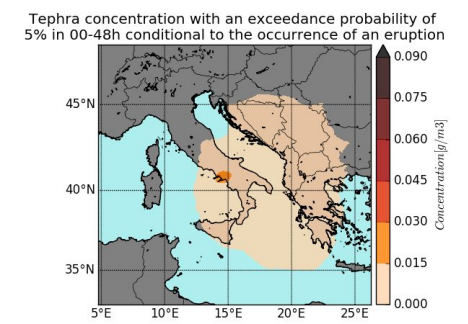
PVHA_WF_st fetches the monitoring data (seismic and deformation) and, together with the configuration file of the volcano, calculates the eruptive forecasting (probability curves and vent opening positions) and uses the output file from  alphabeta_MPI.py to create the volcanic hazard probabilities and maps. 

PVHA_WF_lt uses the configuration file of the volcano to calculate the eruptive forecasting and, together with the output file from alphabeta_MPI.py, creates the volcanic hazard probabilities and maps. 

Meteo data download process is fully automated. PVHA_WF_st and PVHA_WF_lt connect to the Climate Data Store (Copernicus data server) and download the meteorological data associated with a specified analysis grid. These data will later be used to obtain the results of tephra deposition by FALL3D. 

Software involved

FALL3D

Use Case Owner

Laura Sandri
INGV Bologna

Collaborating Institutions

INGV
BSC
IMO