High-Resolution Volcanic Ash Dispersal Forecast
A Use Case by 
Short description
Operational volcanic ash dispersal forecasts are routinely used to prevent aircraft encounters with volcanic ash clouds and to perform re-routings avoiding contaminated airspace areas. However, a gap exists between current operational forecast products (e.g. issued by the Volcanic Ash Advisory Centers) and the requirements of the aviation sector and related stakeholders. Two aspects are particularly critical: 1) time and space scales of current forecasts are coarse (for example, the current operational setup of the London VAAC at U.K. Met. Office outputs on a 40 km horizontal resolution grid and 6 hour time averages) and; 2) quantitative forecasts. Several studies (e.g. Kristiansen et al., 2012) have concluded that the main source of epistemic/aleatory uncertainty in ash dispersal forecasts comes from the quantification of the source term (eruption column height and strength) which, very often, is not fully-constrained on real time. This limitation can be circumvented in part by integrating into models ash cloud observations away from the source, typically from satellite retrievals of fine ash column mass load (i.e. vertical integration of concentration). Model data assimilation has the potential to improve ash dispersal forecasts by an efficient joint estimation of the (uncertain) volcanic source parameters and the state of the ash cloud.
Results & Achievements
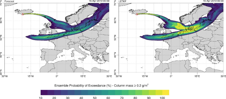
Implementation of ensemble forecasts in FALL3D to run different ensemble members (realizations) as a single model run.
A new workflow component has been developed to retrieve ash (and SO2) cloud column mass from last-generation satellite instrumentation.
A new satellite data assimilation module based on the Parallel Data Assimilation Framework (PDAF) has been implemented.
Objectives
Volcanic ash cloud forecasts are performed shortly before or during an eruption in order to predict expected fallout rates in the next hours/days and/or to prevent aircraft encounters with volcanic clouds. These forecasts constitute the main decision tool for flight cancellations and airplane re-routings avoiding contaminated airspace areas. However, an important gap exists between current operational products and the actual requirements from the aviation industry and related stakeholders in terms of model resolution, frequency of forecasts, and quantification of airborne ash concentration. This pilot demonstrator is implementing an ensemble-based data assimilation system (workflow) combining the FALL3D dispersal model with high-resolution geostationary satellite retrievals in order to furnish high-resolution forecasts
Technologies
Workflow
Use case workflow includes the following components:
The download and pre-process of required meteorological data.
The download of raw satellite data and the cloud mass quantitative retrievals (SEVIRI retrievals at 0.1º resolution, 1-hour frequency).
The ensemble forecast execution using the FALL3D model (i.e. the HPC component of the workflow)
No WMS available yet (work in progress)
Software involved
Use Case Owner
Arnau Folch
Barcelona Supercomputing Center-Centro Nacional de Supercomputación (BSC-CNS)
Collaborating Institutions
BSC
INGV
IMO